

Reflecting Walls · FAA-licensed drone pilots
Real Estate Drone Photography in Phoenix, Scottsdale & Mesa
Aerial photos and video for homes, land, new communities and commercial properties across the Phoenix metro. Drone photos start at $99, and our pilots handle the airspace authorization for you.
Part 107FAA-licensed pilots
InsuredCommercial liability coverage
$99Drone photos from
950 acresLargest land coverage
Quick facts What drone shows Pricing Airspace by city Commercial & land FAQs
Arizona real estate drone photography at a glance
- Who we serveReal estate agents, home builders, land sellers, developers and commercial property owners across the Phoenix metro
- What we flyAerial photos, aerial video, land and lot coverage up to about 950 acres, lot lines and map markers, and recurring construction progress capture
- PriceDrone photos $99 · drone video $199 · land and lot drone from $199 · lot lines $50 · map markers $40
- PilotsFAA Part 107 remote pilots with commercial liability insurance. We get FAA (LAANC) authorization wherever the airspace requires it
- WherePhoenix, Scottsdale, Mesa, Chandler, Gilbert, Tempe, Glendale, Peoria, Surprise, Goodyear, Buckeye and the rest of the Valley
- How to bookAdd drone to any photo order at reflectingwalls.com/order, or call 480-469-8780
Why add drone
What a drone shows that a ground photo can’t
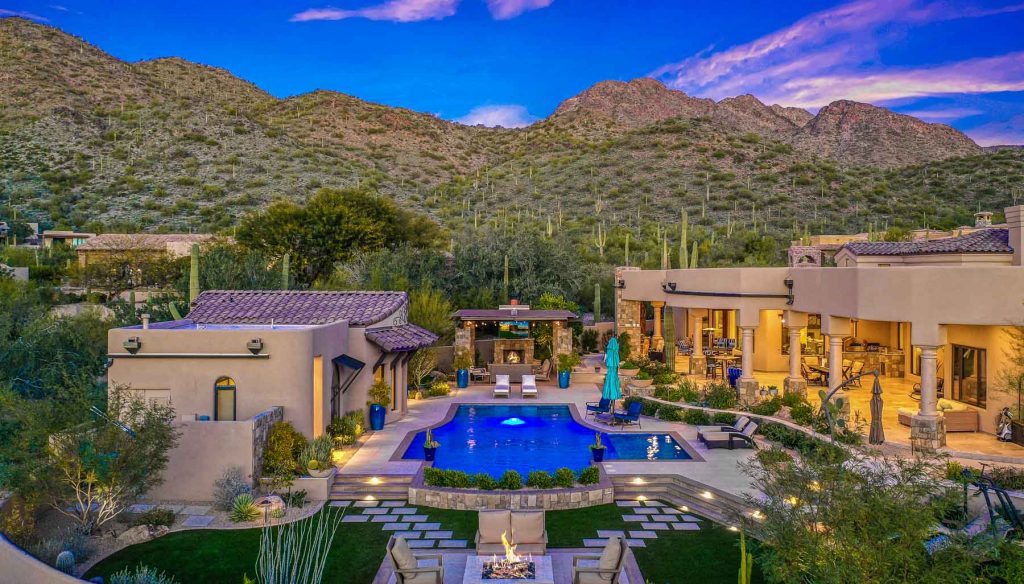
In Arizona, the setting often sells the home: the mountain view, the golf course, the lake, the acreage or the distance to the next house. Aerial photos put that in the first few images buyers see.
Views and setting
Camelback, Piestewa Peak, the McDowells, Usery Mountain or the Sierra Estrella behind the home, and the golf course, lake or preserve next to it.
Lot size and privacy
How big the lot is, where the property lines run, the RV gate or horse setup, and how private the backyard and pool really are.
Location context
How close the home is to parks, schools, trails, shopping and the freeway, with optional map markers that label what matters.
Land and acreage
Large-parcel coverage for land listings and lots up to about 950 acres, with lot lines drawn on the photos.
New communities
Model homes, amenity centers and phase progress for builders. See our home builder services.
Commercial properties
Retail, office, industrial, multifamily and hospitality from the air. See commercial real estate media.
Drone pricing
Arizona drone photography prices
These prices come from our Arizona order form. Booking drone with photos, video or a 3D tour in one appointment applies a package discount automatically.
Most common
Drone photos
$99
Aerial photos of the home, lot and surroundings, edited to match your listing photos.
Motion
Drone video
$199
Smooth aerial clips for your listing video, social media and the MLS. Pairs well with an HD or cinematic property video.
Large parcels
Land / lot drone
From $199
Coverage for land listings and properties up to about 950 acres. Build your order for the exact price.
Lot lines: $50
Property boundaries drawn on up to 8 drone photos, so buyers see exactly what’s included.
Map markers: $40
Labels for nearby schools, parks, trails, golf courses or shopping on your aerial photos.
Construction tracking: quote
Recurring aerial progress photos for homes and communities under construction. Ask about builder services →
Local airspace knowledge
Flying drones legally across the Phoenix metro
The Valley has some of the busiest airspace in the country. Our pilots check every address before the shoot and request FAA (LAANC) authorization wherever it’s required, so you never have to think about it.
Phoenix
Much of central Phoenix sits inside Sky Harbor’s Class B airspace, and Deer Valley Airport has its own controlled airspace in the north. Drone photos show Camelback or Piestewa Peak behind the home, the size of an Arcadia lot, or the distance to the preserve.
Scottsdale
Scottsdale Airport’s controlled airspace covers the Airpark area and Sky Harbor’s Class B reaches south Scottsdale. We never launch from the McDowell Sonoran Preserve. In north Scottsdale the drone shows the golf course, the McDowells or Pinnacle Peak, and how private the lot is.
Mesa
Falcon Field has controlled airspace in north Mesa, and Phoenix-Mesa Gateway’s Class C airspace covers southeast Mesa near Eastmark. Drone photos show the mountain and golf views that set northeast Mesa homes apart.
Chandler
Chandler Municipal Airport has its own controlled airspace and Sky Harbor’s Class B covers north Chandler. Flights over the Gila River Indian Community need its permission. Drone shows lake frontage in Ocotillo and greenbelt or golf views.
Gilbert
Phoenix-Mesa Gateway’s Class C airspace covers southeast Gilbert and Chandler Municipal’s controlled airspace touches the southwest. Drone shows the lake in Val Vista Lakes or the greenbelt behind a Morrison Ranch home.
Tempe
Much of Tempe is inside Sky Harbor’s Class B airspace with low altitude limits, and Mountain America Stadium has a temporary flight restriction on ASU game days. We tell you up front if a drone shot isn’t possible at an address.
Glendale
Luke Air Force Base, Glendale Municipal Airport and Sky Harbor’s airspace all touch Glendale, and State Farm Stadium has a temporary flight restriction on event days. Drone shows Arrowhead lake and golf lots.
Paradise Valley
The town sits under Sky Harbor’s Class B airspace near Scottsdale Airport’s controlled airspace, so every flight is authorized first. Drone shows the acreage, privacy and views of Camelback or Mummy Mountain.
Goodyear
Phoenix Goodyear Airport has controlled airspace in central Goodyear and Luke Air Force Base’s airspace is just to the north. In Estrella, the drone shows the lake, the Sierra Estrella and the space around the lot.
City pages: Phoenix real estate photography · Scottsdale real estate photography · Mesa real estate photography · Chandler real estate photography · Gilbert real estate photography · Tempe real estate photography · Glendale real estate photography · Paradise Valley real estate photography · Goodyear real estate photography
Commercial, land and construction
Commercial drone photography in Phoenix, Scottsdale and Mesa
Commercial listings, leasing campaigns and developments need aerials that show scale, access and surroundings: the frontage on a busy corridor, the parking field, the freeway interchange a minute away, or the land around a future project.
We fly retail centers, office buildings, industrial and flex space, multifamily communities, hotels and raw land. For projects under construction, we capture the same angles on a recurring schedule, so owners, lenders and investors can see progress from one visit to the next.
Commercial real estate media → Home builder and construction tracking →
What commercial drone includes
- Aerial photos and video of the property and surroundings
- Frontage, access, parking and nearby traffic generators
- Land and acreage up to about 950 acres
- Lot lines and map markers on the photos
- Recurring construction progress capture
- Ground photography and 3D tours in the same visit
Why agents book us
Why Arizona agents book their drone with Reflecting Walls
One appointment
The same visit covers photos, drone, video, 3D tours and floor plans, so your seller only has the house photo-ready once.
Licensed and insured
Every pilot holds an FAA Part 107 certificate and we carry commercial liability insurance. We handle airspace authorization.
Edited to match
Aerials are color-matched to your listing photos, so the whole gallery looks like one shoot.
 Google
I have been a real estate investor for years now and always use RW.
I have used this company to shoot 6 listing photos since March. They are incredible to work with!
1. Super professional and great customer service.
2. Quality product and always take the right angles.
3. Easy and flexible when it comes to booking apts last minute.
4. Priced competitively in the marketplace and save $175 per shoot from what I paid prior.
 Google
The Reflecting Walls team is excellent! They photographed my home some years back and the pictures were stunning. They sent me a notice several months back that my photos were being archived. Yesterday, I had some emergency edits that I needed to have done ASAP. They bent over backwards to accommodate me. I am so grateful. I sincerely thank Landry, Kelsey, and Austin for your kindness. You all are amazing! God bless you!
 Google
Phenomenal experience
 Google
Best real estate photos and videos on the market! If your a realtor looking for a fast easy to work with photography company these guys rock! Austin has been an absolutely essential part of selling my listings!
 Google
The video and photographs he took in over 7 hours at our house are probably the reason it was sold after just a week listed.
Thank you for your awesome work and the super cool video of our little ranch.
 Google
I had a great experience working with Austin and Reflecting Walls Photography. Their communication was timely, professional, and easy throughout the entire process. I chose them because of their experience and the fact that their work has been featured in high-end publications, which really showed in the quality and attention to detail. I will definitely be using them going forward and would highly recommend them to anyone looking for a reliable and skilled photography team
 Google
I hired Austin and Reflecting Walls Photography for a custom project to photograph our commercial solar lighting systems installed at live job sites around the Phoenix area. Austin did an excellent job from start to finish, understanding our needs and the scope of the project, and executing my vision flawlessly. The images are a core part of our new website and brand redesign, and I couldn't be happier with the work he did. Thank you!
 Google
Great company to work with. Fast and friendly service. Thank you!
 Google
Higher than 5 stars really. To put it very simple, just give Austin the canvas and behold at his creativity. Super professional, focused with upbeat energy, and delivery on or before due date. Austin and his team are exceptional!
 Google
I had a wonderful experience with Austin at Reflecting Walls photography! He is very professional and knowledgeable. My video and home photos turned out perfect!!
 Google
Austin is a true professional who shows up on time and focuses on the finished product throughout the entire process. A man of his word with a great work ethic. Lots of great qualities that are unfortunately hard to find in people now and he caps that off with a deep passion for his work. The project was even completed ahead of schedule. I won’t even consider ever working with another company!
 Google
Austin did a wonderful job with our home photos. He is a great guy!! Would highly recommend him for your home sale!

Who’s behind your photos
Meet Austin DuBois, Arizona Branch Manager
Austin DuBois co-founded Reflecting Walls with his brother Jordan in 2014, after the two built the photography operation for their family’s real estate group in Arizona. Today Austin runs company operations and the Arizona branch, which is headquartered in Surprise and photographs Phoenix-area listings every week.
Austin is still behind the camera, shooting high-end homes and video for our Luxury Division. He sets the capture and editing standards every Arizona photographer is trained on, so a listing shot on Monday looks like one shot on Friday, whoever is holding the camera.
About Reflecting Walls and our founders → Why agents hire us →
FAQs
Real estate drone photography in Arizona: common questions
How much does real estate drone photography cost in Arizona?
Drone photos start at $99 and drone video is $199. Land and lot drone coverage starts at $199, lot lines are $50 and map markers are $40. Booking drone with photos, video or a 3D tour applies a package discount automatically.
Are your drone pilots licensed?
Yes. Every pilot holds an FAA Part 107 remote pilot certificate, and we carry commercial liability insurance. We check the airspace for every address and get FAA (LAANC) authorization wherever it’s required.
Can you fly a drone near Sky Harbor, Scottsdale Airport or Falcon Field?
Often, yes, with FAA authorization and lower altitude limits. Some addresses close to the airports, and stadiums on event days, can’t be flown. If a drone shot isn’t possible at an address, we tell you before the shoot.
Is drone photography worth it for a listing?
For homes with views, golf, lake, greenbelt or preserve lots, larger lots, acreage, horse properties and luxury homes, almost always. For an interior lot in a dense subdivision, photos plus a 3D tour and floor plan usually do more for the price.
Should I order drone photos, drone video or both?
Drone photos give buyers location and lot context at a glance on the MLS. Drone video adds motion for your listing video and social media. Many agents order both for luxury and view homes.
Do you fly drones for commercial properties and land?
Yes. We fly retail, office, industrial, multifamily, hospitality and land, including parcels up to about 950 acres, plus recurring construction progress capture. Contact us for a commercial quote.
Service area
Where we fly
Our Arizona team is based in Surprise and flies across the Phoenix metro every week. Properties farther than about 30 miles from ZIP 85387 may have a travel fee, depending on distance and order size.
Arizona city pages
- Avondale
- Buckeye
- Cave Creek
- Chandler
- Gilbert
- Glendale
- Goodyear
- Mesa
- Paradise Valley
- Peoria
- Phoenix
- Scottsdale
- Sun City
- Sun City West
- Surprise
- Tempe
Shooting in Illinois? See Illinois drone pricing.
Add drone to your next Arizona listing
Build your order in a couple of minutes, or call and we’ll tell you whether drone is worth it for the property and check the airspace for you.